 |
| Holes (PAS) |
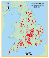
The tone is far stronger than the current pulling of punches on the PAS website. Well, Hurrah! But for many years we’ve published HUNDREDS of articles begging for that to happen. [...] Anyhow, as a matter of interest, here’s one of our earliest complaints, from nearly 16 years ago.And the British Archaeology article (kindly made available by Professor Michael Lewis, Head of PAS one of the authors) contains a figure that makes that point. Each angry red spot on that map is a hole ripped out of the archaeological record.At first sight there do not look to be 546 dots on that map, and 546 is the number of rallies "the PAS is aware of" from its liaison, and does not include the various club events held almost weekly up and down the country for fifteen or more years until the outbreak of the current pandemic. But when you look closer (apologies for the graininess produced by the resolution of the pdf I received from Bloomsbury), we see there are clusters of heritage destruction running right through the Midlands, 26, 12, 91, 17, 16 and 17 sites at this scale have just blurred (and there's another cluster of 6 sites up North around Carlisle).Shameful Heritage plunder near Avebury, Sunday 24 April 2005 [...] Those fields, classed as disturbed plough soil – “so it’s legal, innit” are packed with our common history, from palaeolithic scatters onwards. Or at least, they were. As it happened, the 480 people who ‘hoovered’ these 2 fields last Sunday reckoned very little was found. Maybe that’s true, maybe not. How would anyone know? Maybe, as many of them claimed, it was because “those fields were done over” by a similar rally 10 years ago. Whatever the truth, when the full and detailed account of our past is written, those 170 acres in the heart of this vitally archaeologically rich area will forever show up as a blank in the record. Shame on them! And shame on the thinking members of the hobby for tolerating such selfish and ignorant behaviour from the majority. Shame on the management of the Portable Antiquities Scheme. The Scheme’s management must find the moral courage to loudly proclaim what is and isn’t civilised.[They have now! 16 years later! – Ed.]
This, too, introduces yet another bias into the PAS database, material recovered from such blanket-stripping of productive areas will differ from the single-finds of individual searching, yet the evidence from rallies is not distributed evenly, it clusters in a specific geographical zone, so if you were using PAS data to study, for example medieval settlement geography, you'd find the data biased to a zone of England that has a specific geographical pattern of settlement and land use in the Middle Ages - which is another reason why PAS data are useless for research of this type (PMB paper coming out early next year on this).


No comments:
Post a Comment