 Following on from my earlier post (above) about the FOI request to English Nature of metal detectorist John Stokes (Senior Countryside Officer at Sandwell MBC, Walsall, UK), it seems there is a problem in the UK deciding what in terms of the rural landscape an archaeological site is and how it can be damaged. The information supplied 15th June 2011 in reply to the request (Request No 1146; RFI#1146) by one Jez Bretherton, Historic Environment Senior Specialist in English Nature was pretty thought-provoking. Fittingly, the reply was published on the "What do they Know?" website (WhatDoTheyKnow.com). He says:
 Metal detecting is not banned on land under an Environmental Stewardship (ES) Scheme, it is facilitated in appropriate circumstances.One wonders what the "appropriate circumstances" there might be for the recreational destruction of archaeological evidence. What are they and do they apply only in rural England, or can one generalise and create guidelines for the stripping of collectable artefacts from sites in Iraq, or maybe the sands of the Sahara Desert (see here also), or the ancient sites of the Four Corners region of the USA?
Anyway, English Nature has its Handbook which:
clarifies the person with the ES Agreement must ensure that no damage is caused to (known environmental) features, and any additional features of which you are subsequently advised in writing by Natural England, wherever metal detecting takes place.What it does not say is that when clusters of archaeological artefacts removed from ES Agreement land for collection or sale by artefact hunters start to appear in the records of the PAS, that there is any mechanism whatsoever that leads to their assessment as (now) known archaeological suites and whether their preservation is desirable. It basically looks as if in typical british-muddling-through manner, a half-baked system has been set up which would make sites 'known' but in fact nobody gets to know about them or stop their depredation under the ES Agreement which should be protecting them. Now, why is that?
Even more startling is the definition of "damage to archaeological sites". In the view of the government environmental conservation agency English Nature this:
is taken to mean disturbance of previously undisturbed deposits in and on archaeological sites and monuments, and any removal, loss and/or disruption of standing masonry or other upstanding structural material.The bit about "any removal, loss and/or disruption of standing masonry or other upstanding structural material" on an archaeological site is a bit of a no-brainer, but wholly unclear is the nature of surface evidence. What English Nature are saying is the equivalent to saying that a copse of 100-year old beech trees is damaged, not when eight out of ten of the trees are cut down and carted away for firewood, but only if the roots are dug out. In the case of the English landscape (as across most of lowland Europe) many sites are represented only or mainly by the patterns of artefacts and other material resulting from or modified by human activity in the past in the topsoil layers. The study of landscape use in the past consists to a large degree in many landscapes in the study of those patterns, with only limited sampling by excavation. These are techniques that have been developing since the 1960s/1970s with a huge literature going back many decades and yet wholly ignored by English Nature definition of "archaeological site" and its definition of "damage to archaeological sites". English Heritage's policy document "Our Portable Past" is one of the places where policy is laid down how these types of sites are to be examined and treated, one would have thought that in the case of sites which lie on land the conservation of which is supposed to be assured by English Nature-administered environmental schemes, such a manner of data-gathering would be the minimum required.
It should be pointed out that this definition of "previously undisturbed deposits in and on archaeological sites and monuments" is not precise enough to be used. For example a site may consist of active modern ploughsoil overlying a fossil ploughsoil (for example accumulated at the base of a slope or on a lynchet) which is also "previously disturbed" (how "previous" is "previous"?). By definition, most of the layers forming an archaeological site are "disturbed", they've been put there by human or natural agencies on top of the undisturbed geological substrate.
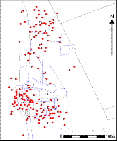 The plot of metal finds (versus cropmarks) at Cottam from the VASLE project is a clear illustration that the distribution of material in ploughsoil is not random, but contains several levels of archaeological information which can only be interpreted properly when the data are collected systematically and properly. Removing these artefacts from the topsoil without following that data gathering procedures destroys for ever not only the information content of the removed artefacts, but our ability to interpret the site itself from which they were taken. Like somebody stealing the murder weapon and other 'souvenirs' from a crime scene before the cops' forensic team arrives. Damage IS done to the archaeological record by the improper removal of items from patterned asemblages in the topsoil and ploughsoil. It is a shame that English Nature does not know it, or acknowledge it. Scandal.
Vignette: top VASLE project, Cottam metal finds distribution in ploughsoil


No comments:
Post a Comment